
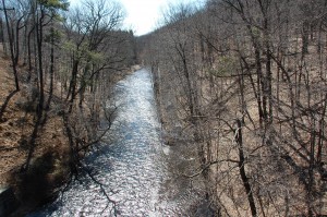
Millington Gorge
At river mile 1.7, as I prepare to paddle under the bridge at South Maple Avenue in Basking Ridge, I hear Carl call out from behind me. “The Gorge,” he says, pointing downstream. Millington Gorge must be just ahead. I paddle back to Carl. He has pulled his kayak up to a gauge station on the riverbank to check the water depth. The Millington Gorge is a narrow cobbled chute through the broken hills that make up the westernmost Watchung ridge. This is where the Passaic exits the Great Swamp. The gorge was carved, or rather worn away, some 10,000 years ago by the overflow waters from Glacial Lake Passaic. Millington Gorge is not a spectacular sheer-sided vault like the gorges out west. Its steep banks are forested for one thing – Eastern Redbud, Shagbark Hickory, River Birch, and splashes of pink from the occasional Dogwood tree and viburnum bush. But the Passaic runs downhill through here and it runs fast. When Carl first kayaked the Gorge in June 2003, the river was at flood stage. Heavy rains, unusual for that time of year, had whipped the drowsy Passaic into a torrent. “That was a thrill ride,” says Carl. “You were just getting your river legs when you were thrown into this shotgun.”
The early morning clouds have given way now. Shafts of sunlight poke through the canopy and dapple the shaded riffles before us. I watch a red-bellied sapsucker scale the trunk of an Eastern Redbud tree. A towhee and a common yellowthroat are singing somewhere close by, well concealed in the understory. The gauge station is a square wood-shingled shack at the water’s edge. It looks like an outhouse. “4.8,” says Carl, reading the gauge. That’s about an inch below the minimum depth that New Jersey paddling guru Edward Gertler recommends for passage through the Gorge without “dragging.” Gertler’s book, Garden State Canoeing: A Paddler’s Guide to New Jersey, is the paddler’s bible.
We proceed anyway and learn pretty quickly that Gertler is right about the water depth. The current whisks us into the Gorge. Our boats bump and scrape along the stones on the river bottom. At times, the Pungos simply grind to a halt, beached on a cobble or two, and no amount of paddle poling or hip thrusting will dislodge them. At one point, the very center of my boat gets caught up on a sharp rock and the Pungo begins to rotate in the current like a compass needle. A father and his two young daughters playing on the steep bank wave in sympathy as Carl and I step out of the kayaks and maneuver them into a deeper part of the channel. We are forced to perform this operation at least a half dozen times through the mile-long Gorge. Visions of a “thrill ride” fade after the third time I climb out of my boat. Carl and I didn’t run the Millington Gorge this day; we more or less walked it.
Still, it’s something of a miracle that Carl and I are even on this upper part of the Passaic River. Most of New Jersey’s wild spaces have come under siege at one time or another, and the land in this part of the Passaic River Basin is no exception. In 1959, the New York Port Authority tried to turn Great Swamp–all 7,600 acres, along with chunks of bordering Chatham, Long Hill, Madison and Harding-into an international airport. It took ten years and a lot of lobbying before local citizens finally foiled the airport plan. They convinced Congress to declare the Swamp a National Wilderness Area, which put the land permanently off limits to development of any kind. In 1968, the U.S. Army Corps of Engineers proposed damming this whole stretch of river and flooding the Millington Gorge. The idea, to essentially recreate a portion of Glacial Lake Passaic, was one of several flood control solutions that the Corps came up with after Congress directed it to study the Passaic River flooding problem in 1936. Local activists ultimately defeated the dam proposal and saved the Millington Gorge for paddlers like Carl and me.
The battle for the Gorge gave birth to the Passaic River Coalition (PRC), the oldest and most well known Passaic River advocacy group. It also launched a decades-long public debate over what to do about Passaic River flooding.
Despite today’s low water, hydrology experts agree that the Passaic is one of the most flood prone river systems in the U.S. For more than 150 years, public officials and their floodplain constituents have tried to contain the river, digging ditches through wetlands to improve drainage, widening and dredging the river’s channel to ease flow, and constructing dams and reservoirs to keep storm water at bay. But the Passaic just keeps on flooding.
The geology of the river’s basin is a principal cause of flooding. Development in the river’s floodplain is the reason the flooding is so costly.
Every time the Passaic transits the Watchung mountains¬-at Millington Gorge, further north at Little Falls, and finally at Great Falls in Paterson-the flood risk rises. The mountain gaps aren’t wide enough to accommodate large volumes of water, the kinds of flow generated by storms and by the annual spring melt. When high water chokes these funnels, the river backs up and spreads out into its broad floodplain and surrounding wetlands. Which is as it should be. Floodplains and wetlands exist to absorb excess water. Except that three million people live in the Passaic River Basin. The floodplain and most of its adjoining wetlands are chock full of housing and industrial developments. The Army Corps puts the number of homes and businesses in the Passaic River floodplain at more than 20,000. So when the Passaic rises up to reclaim its floodplain, river water inundates backyards and basements and factory floors and showrooms all across north central Jersey.
Since 1900, Passaic River floodwaters have killed 26 people and caused $4.5 billion dollars in damage to homes, businesses and the environment. Every flood for the last 40 years–in 1968, 1971, 1972, 1973, two in 1975, 1984, 1992, 1999, 2005, and 2007–was severe enough to trigger a Federal Disaster declaration. During the April 2007 episode, the third worst flood on record, rescue teams had to evacuate 5,000 people in 11 counties. Things were so bad in the aftermath of that April ’07 deluge that the Internal Revenue Service actually extended its April 15th filing deadline for floodplain residents.
All excerpts from This American River: Paradise to Superfund, Afloat on New Jersey’s Passaic are the copyrighted property of the book’s author Mary Bruno.
Leave a Reply
Want to join the discussion?Feel free to contribute!